Modeling the Tsunami of 22 November 2016 in Fukushima
IRIDeS, Tohoku University, Tsunami engineering laboratory
Summary
- On November 22, 2016, a M7.4 earthquake occurred 37 km east of Fukushima Prefecture, Japan, at 05:59 JST. The earthquake triggered the tsunami of up to 1.4-meter height to the northeast and east side of Japan. This page will be updated from time to time with relevant information.
Tsunami simulation and observation
Tsunami Propagation Model Calculated by Tsunami Engineering Laboratory (preliminary result)
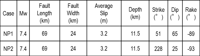
(1) Fault model
- We simulated 2 cases (Table. 1).
Table. 1 Fault parameters.
(2) Numerical simulation
- Grid size: 405 m
Codes: TUNAMI-N2 (Non-linear long wave equation, Imamura et al., 2006)
(3)計算結果
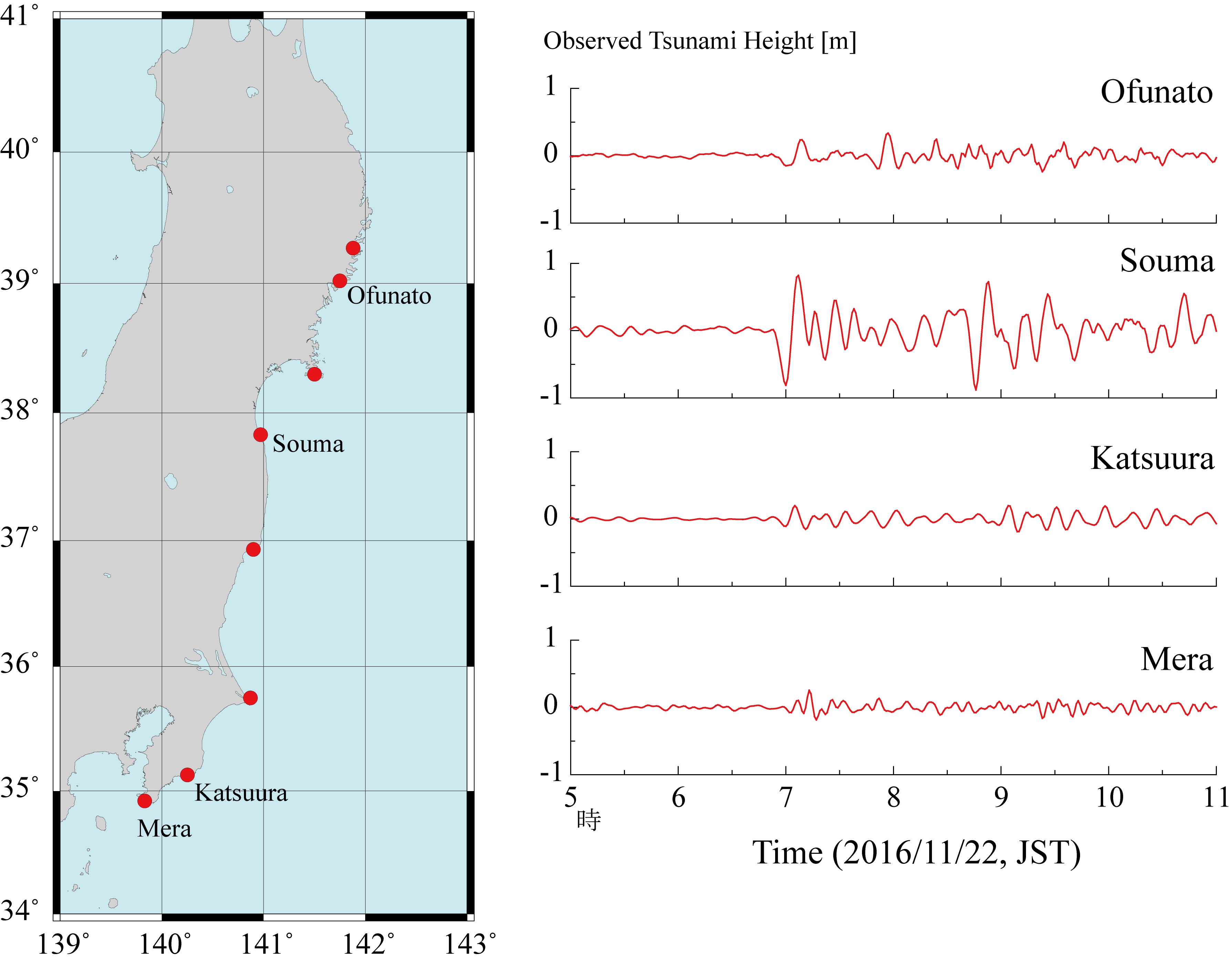
- Simulations well reproduced maximum water level at Ofunato, Sendai and Onahama (Fig. 4).
Fault length and width should be smaller because the first wave trough reaches Soma faster than the actual tsunami.
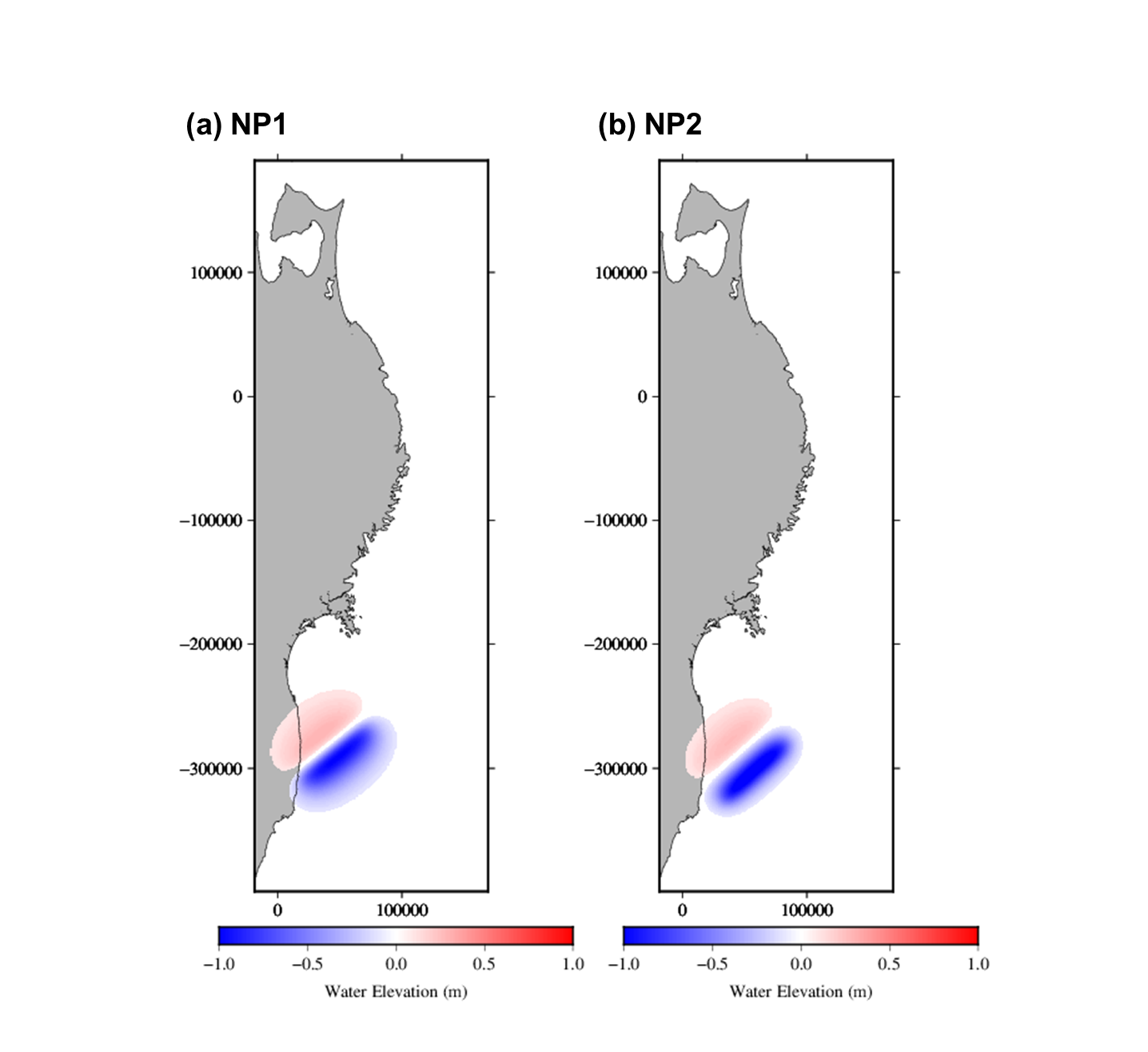
Fig. 1 Deformation. (a) NP1. (b) NP2.
Fig. 2 Movies. (Left) NP1. (Right) NP2.
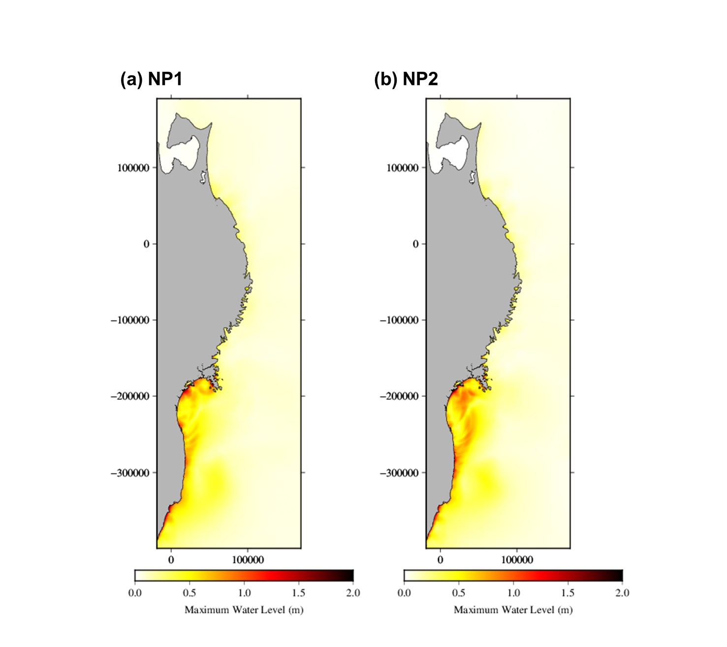
Fig. 3 Maximum water elevation. (a) NP1. (b) NP2.
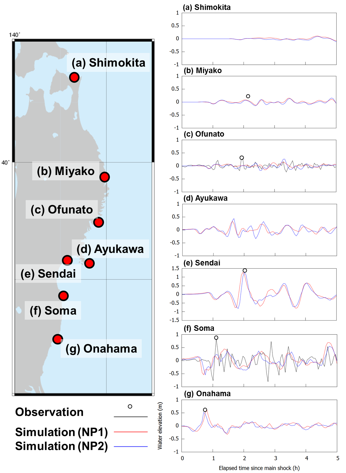
Fig. 4 Waveform. (a) Shimokita. (b) Miyako. (c) Ofunato. (d) Ayukawa. (e) Sendai. (f) Soma. (g) Onahama.
References
- 気象庁,2016a,気象庁報道資料,「平成23年(2011年)東北地方太平洋沖地震」について(第78報) -平成28年11月22日05時59分頃の福島県沖の地震- ,http://www.jma.go.jp/jma/press/1611/22a/201611220800.html
- 気象庁,2016b,気象庁報道資料,「平成23年(2011年)東北地方太平洋沖地震」について(第79報) -平成28年11月22日05時59分頃の福島県沖の地震- ,http://www.jma.go.jp/jma/press/1611/22b/kaisetsu201611221100.pdf
- 防災科学技術研究所,2016/11/24アクセス,http://www.hinet.bosai.go.jp/topics/off-fukushima161122/?LANG=ja&m=mecha
- Imamura et al., 2006, TSUNAMI MODELLING MANUAL (TUNAMI model), https://www.tsunami.irides.tohoku.ac.jp/hokusai3/J/projects/manual-ver-3.1.pdf
- Papazachos et al., 2004, G LOBAL RELATIONS BETWEEN SEISMIC FAULT PARAMETERS AND MOMENT MAGNITUDE OF EARTHQUAKES, http://geophysics.geo.auth.gr/new_web_site_2007/download_files/costas_CV/93.pdf
- USGS, 2016/11/24アクセス, http://earthquake.usgs.gov/earthquakes/eventpage/us10007b88#moment-tensor
Tsunami observation
- Tidal obervation data was got from
http://www1.kaiho.mlit.go.jp/KANKYO/TIDE/real_time_tide/sel/index_e.htm
and processed by filtering program.
Social Side Summary of This Event
1. Japan Meteorological Agency (JMA)'s Tsunami Warnings and Advisories
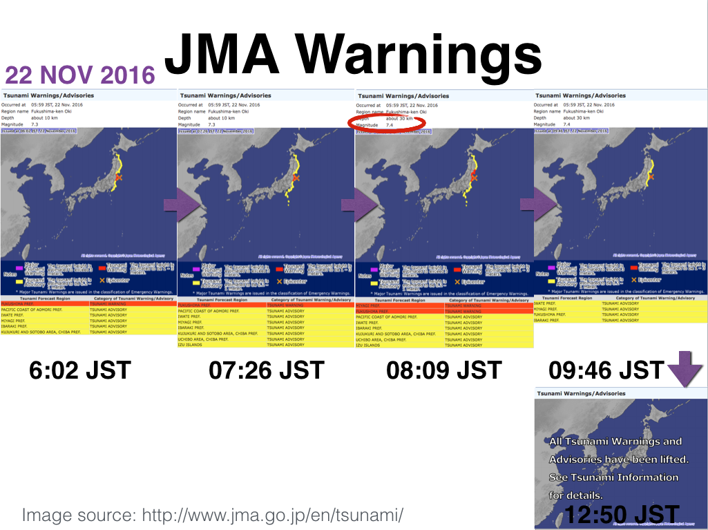
- On November 22, 2016, due to the M7.3 earthquake (the announced magnitude at that time) the Japan Meteorological Agency (JMA) issued the first Tsunami Warnings/Advisories at 6:02 JST. The message contained the Tsunami Warning for Fukushima Prefecture and Tsunami Advisories for Pacific Coast of Aomori Prefecture, Iwate Prefecture, Miyagi Prefecture, Ibaraki Prefecture, and Kujukuri and Sotobo area in Chiba Prefecture.
At 7:26 JST, the Tsunami Advisories were included Uchibo Area of Chiba Prefecture and Izu Islands. At 8:09 JST, Miyagi Prefecture was upgraded to the Tsunami Warning. In addition, the magnitude was changed from M7.3 to M7.4 and the depth was changed from 10 km to 25 m. At 9:46 JST, the Tsunami Warnings were downgraded to the Tsunami Advisories. The advisories covered Iwate Prefecture, Miyagi Prefecture, Fukushima Prefecture, and Ibaraki Prefecture.
As shown in Figure 1 (bottom-right), at 12:50 JST, JMA lifted all Tsunami Warnings and Advisories
Note. The graphs are created by GNS Science (Licensed under a Creative Commons Attribution 3.0 New Zealand License).
Evacuation Behaviors in the event
- Evacuation behaviors in coastal areas in Tohoku arose due to the strong tremor and tsunami warning in this event. No significant damage was observed in the event. However, the event revealed some existing problems, especially car usage in evacuation behaviors during tsunamis.
The problem of car evacuation was also pointed out in the 2011 Tohoku tsunami, and the discussion on this point is still ongoing1). Before the 2011 tsunami, car evacuation in tsunamis was strictly prohibited due to possible traffic jams that disturb smooth evacuations. Based on the lesson that some vulnerable people such as people living wide plain area and people with disabilities were hard to get safe places during the tsunami, car evacuation is now partly allowed in accordance with situations in local communities. Note that on-foot evacuation is still the fundamental way to evacuate during tsunamis except in special situation discussed above.
However, in reality, there are excessive car evacuation demands due to following reasons: Car itself is expensive assets, people can bring many kinds of stuff with cars, people can have a privacy space after evacuation, as some researchers have been pointed out4), 5), 6). Therefore, continuous discussions and consensus building are needed to be done in local communities as lessons learned from the 2011 tsunami. Since these kind of activities are not enough, excessive car use and traffic jams were again observed in this event. Some scenes of traffic jams are available through SNS such as Twitter. Because the earthquake and tsunami occurred in the early morning, it is suggested that car use demand for evacuation and for business commute were partly combined together and caused traffic jams at some points.
Based on the facts observed in this event, discussions for better evacuation is ongoing in media including SNS. One of attracting tool for better evacuation, tsunami evacuation simulation, can contribute to solving this problem, and Tsunami Engineering Laboratory in IRIDeS has been devoted to developing this tool. Tsunami evacuation simulation can simulate human evacuation behaviors and tsunami hazard in virtual city environments in computers and offer quantitative useful suggestions for future tsunami evacuations in local communities that are necessary for making local evacuation rules and better consensus building. However, it will work well based on discussions by local residents in local communities. Organizing lessons from this event as well as the 2011 tsunami and its practical implementation in local communities are key actions for future better tsunami evacuations.
References for Chapter 2
-
- Suppasri, A., Latcharote, P., Bricker, J. D., Leelawat, N., Hayashi, A., Yamashita, K., Makinoshima, F., Roeber, V. & Imamura, F. (2016). Improvement of tsunami countermeasures based on lessons from the 2011 great east japan earthquake and tsunami -Situation after five years-, Coastal Engineering Journal, 58(4). doi: 10.1142/S0578563416400118
- Guidance for tsunami countermeasures in local disaster prevention plan (1998. 3). Retrieved from http://tsunami-dl.jp/document/022
- Rules for Traffics in Japan (2011.3). Retrieved from https://www.npa.go.jp/koutsuu/kikaku/kyousoku/index.htm
- Sun, Y., Nakai, F., Yamori, K., & Hatayama, M. (2016). Tsunami evacuation behavior of coastal residents in Kochi Prefecture during the 2014 Iyonada Earthquake, Natural Hazards. doi: 10.1007/s11069-016-2562-z
- 今村文彦(2014)津波の避難行動と減災対策〜東日本大震災の教訓を踏まえて〜、緊急時、災害時の人間行動と欧州文化相互影響調査(シルク・シュミット、エド・ガリア編)*Book abvailable in Japanese
- Makinoshima, F., Imamura, F., & Yoshi Abe: Behavior from Tsunami Recorded in Multimedia Sources at Kesennuma City in the 2011 Tohoku Tsunami and Its Simulation by Using Evacuation Model with Pedestrian-Car Interaction. Coastal Engineering Journal. doi: 10.1142/S0578563416400234
Timeline of Tsunami Engineering Laboratory Procedure
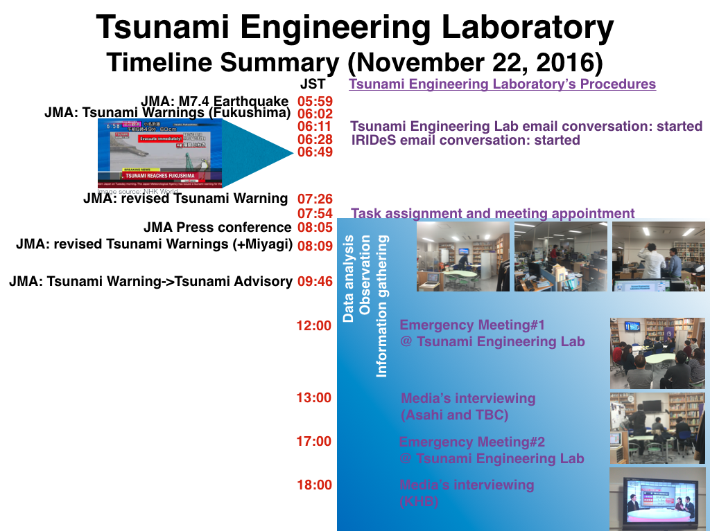
- After the occurrence of the M7.4 earthquake on November 22, 2016, Tsunami Engineering Laboratory members have started discussing and sharing related information via email since 6:11 JST, followed by the IRIDeS members’ email conversation started at 6:28 JST.
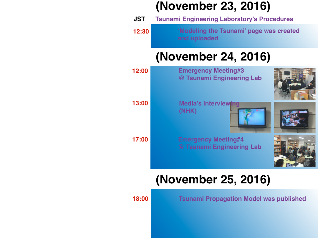
The tasks have been assigned to the laboratory’s members at 07:54 JST. We set three teams including data analysis team, observation team, and information gathering team. The first emergency meeting was fixed at 12:00 JST. At the meeting, all teams presented their preliminary findings and discussed with others.
Asahi and TBC conducted the interviews about the event after the first meeting.
After that, all teams continued working on their assigned tasks preparing with more concrete and detailed data for the second meeting at 17:00 JST.
KHB conducted the live interview about the event and broadcasted on TV.
Further meeting has been scheduled.
-->

by:
F. Imamura, A. Suppasri, N. Leelawat, P. Latcharote, A. Hisamatsu, F. Makinoshima, M. Watanabe, H. Ohira, Y. Hirakawa, N. Togawa, N. Hasegawa, T. Otake, R. Baba, K. Fukui
(Tsunami Engineering, Hazard and Risk Evaluation Research Division)
S. Sato
(Disaster Digital Archive, Disaster Information Management and Public Collaboration Division)
K. Yamashita, A. Hayashi, Y. Abe
(Earthquake induced Tsunami Risk Evaluation (Tokio Marine), Endowed Research Division)
